Routing Points, Canals, Piracy Routing Lists
Short Description
Currently Dataloy VMS holds more than 8,500 ports and maritime locations and more than 80,000 waypoints (or routing points) that contribute to the accuracy of a calculation. This section lists the most common routing points, all in Dataloy VMS available canals and the piracy routing points that must be entered manually (will never show in a port rotation by default).
Chapters:
Long Description
Common Routing Points
Routing points can be defined as specific locations that a vessel pass through when en route between port calls and are used in Dataloy VMS when scheduling voyage rotation. Each routing point is defined by a unique code and name. When entering a routing point into the voyage calculation, only the routing point code can be used.
The most commonly used routing points:
| Routing Point Names: | Code: |
|---|---|
| Anegada Passage | AP |
| Balabac Strait | BL |
| Basilan Strait | BS |
| Belle Isle | BI |
| Bishop Rock | BR |
| Cape Good Hope | GH |
| Cape Horn | CH |
| Cape Race | CR |
| Cook Strait | CO |
| Dover Strait | DS |
| Great Belt | GB |
| Grenville Channel | GV |
| Jomard Entrance | JE |
| Johnstone Strait | JS |
| Lombok Strait | LS |
| Mona Passage | MP |
| Nanuku Passage | NP |
| North East Passage | NE |
| North West Passage | NW |
| Oresund | OR |
| Osumi Strait | OS |
| Pentland Firth | PF |
| Providence Canal | PR |
| San Bernardino Strait | SB |
| Selat Jailolo | SJ |
| Selat Ombai | OM |
| Singapore Strait | SS |
| Sunda Strait | SU |
| Surigao Strait | SG |
| Tsugaru Strait | TS |
| Virgin Passage | VP |
| Wilsons Promontory | WP |
| Windward Passage | WI |
Canal Passages
Canals are routing points that will by default show as a separate port call in the port rotation in order to address the time and cost involved with canal passages directly to the canal. The canal time and cost has a direct impact on the result and length of a voyage. Each canal is defined by a unique code and name.
Available canal passages in Dataloy VMS:
| Canal Passages: | Code: |
|---|---|
| Bosporus Canal | BO |
| Corinth Canal | CC |
| Kiel Canal | KC |
| Magellan Strait | MA |
| Panama Canal | PC |
| Suez Canal | SC |
| Torres Strait | TO |
Piracy Routing
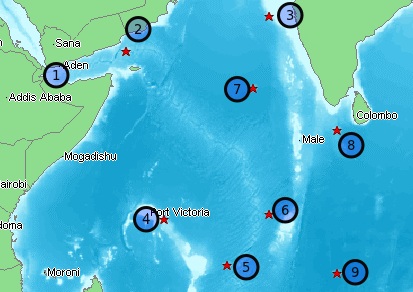
To date, nine piracy routing points have been added to retrieve the most accurate distance based on current routing advice in high risk areas. The piracy routing points are not added to a voyage rotation by default, but must always be entered be manually and only using their respective piracy routing code. Each is defined by a unique code and name.
Available Piracy Routing Points:
Map | No. | Description / Name | RP Code | Latitude | Longitude |
|---|---|---|---|---|---|
| 1 | Gulf Of Aden West Bound | A1 | 11°59'N | 45°00'E |